
Make a donation
Gear up for your next adventure:
As an Amazon Associate, this site earns from qualifying purchases at no extra cost to you.
South Brunswick topographic map
Click on the map to display elevation.
Make a donation
Gear up for your next adventure:
As an Amazon Associate, this site earns from qualifying purchases at no extra cost to you.
About this map
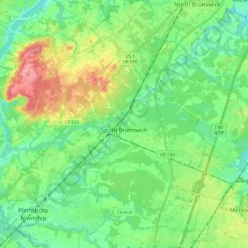
Name: South Brunswick topographic map, elevation, terrain.
Location: South Brunswick, Middlesex County, New Jersey, United States (40.32846 -74.62388 40.44138 -74.43684)
Average elevation: 118 ft
Minimum elevation: 20 ft
Maximum elevation: 335 ft
Middlesex County trails, hiking, mountain biking, running and outdoor activities
Make a donation
Gear up for your next adventure:
As an Amazon Associate, this site earns from qualifying purchases at no extra cost to you.
Other topographic maps
Click on a map to view its topography, its elevation and its terrain.
Six Mile Run
United States > New Jersey > Middlesex County > North Brunswick > Adams
Average elevation: 112 ft
Orchard Heights
United States > New Jersey > Middlesex County > East Brunswick Township
Average elevation: 105 ft
Shore View
United States > New Jersey > Middlesex County > Woodbridge Township > Colonia
Average elevation: 95 ft
Make a donation
Gear up for your next adventure:
As an Amazon Associate, this site earns from qualifying purchases at no extra cost to you.
Make a donation
Gear up for your next adventure:
As an Amazon Associate, this site earns from qualifying purchases at no extra cost to you.
Berdines Corners
United States > New Jersey > Middlesex County > North Brunswick
Average elevation: 95 ft
South Brunswick Terrace
United States > New Jersey > Middlesex County > South Brunswick
Average elevation: 128 ft
Make a donation
Gear up for your next adventure:
As an Amazon Associate, this site earns from qualifying purchases at no extra cost to you.
Woodbridge
United States > New Jersey > Middlesex County > Woodbridge Township
Average elevation: 52 ft
New Market
United States > New Jersey > Middlesex County > Piscataway Township
Average elevation: 75 ft
Make a donation
Gear up for your next adventure:
As an Amazon Associate, this site earns from qualifying purchases at no extra cost to you.
Bicentennial Park
United States > New Jersey > Middlesex County > East Brunswick Township > Farrington Lake Heights
Average elevation: 79 ft
Make a donation
Gear up for your next adventure:
As an Amazon Associate, this site earns from qualifying purchases at no extra cost to you.
Highland Park
United States > New Jersey > Middlesex County > Highland Park > Highland Park
Average elevation: 79 ft
Dunhams Corners
United States > New Jersey > Middlesex County > East Brunswick Township > Dunhams Corners
Average elevation: 108 ft
Middlesex
United States > New Jersey > Middlesex County > Middlesex > Middlesex
Average elevation: 125 ft
Make a donation
Gear up for your next adventure:
As an Amazon Associate, this site earns from qualifying purchases at no extra cost to you.
Farrington Lake Heights
United States > New Jersey > Middlesex County > East Brunswick Township > Farrington Lake Heights
Average elevation: 89 ft
Make a donation
Gear up for your next adventure:
As an Amazon Associate, this site earns from qualifying purchases at no extra cost to you.
Lincoln Park
United States > New Jersey > Middlesex County > New Brunswick > Lincoln Park
Average elevation: 92 ft
Make a donation
Gear up for your next adventure:
As an Amazon Associate, this site earns from qualifying purchases at no extra cost to you.