
Thank you for supporting this site ❤️
Make a donation
Make a donation
Gear up for your next adventure:
As an Amazon Associate, this site earns from qualifying purchases at no extra cost to you.
Gurgl topographic map
Click on the map to display elevation.
Thank you for supporting this site ❤️
Make a donation
Make a donation
Gear up for your next adventure:
As an Amazon Associate, this site earns from qualifying purchases at no extra cost to you.
About this map
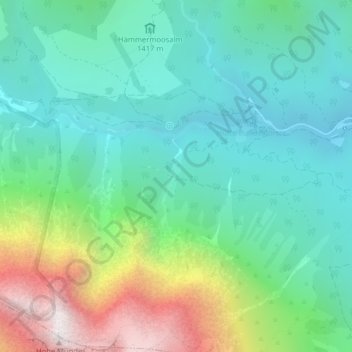
Name: Gurgl topographic map, elevation, terrain.
Location: Gurgl, Leutasch, Bezirk Innsbruck-Land, Tyrol, 6105, Austria (47.34986 11.07497 47.36986 11.09497)
Average elevation: 5,262 ft
Minimum elevation: 3,947 ft
Maximum elevation: 8,688 ft
Thank you for supporting this site ❤️
Make a donation
Make a donation
Gear up for your next adventure:
As an Amazon Associate, this site earns from qualifying purchases at no extra cost to you.
Other topographic maps
Click on a map to view its topography, its elevation and its terrain.