
Make a donation
Gear up for your next adventure:
As an Amazon Associate, this site earns from qualifying purchases at no extra cost to you.
Schwarzenacker topographic map
Click on the map to display elevation.
Make a donation
Gear up for your next adventure:
As an Amazon Associate, this site earns from qualifying purchases at no extra cost to you.
About this map
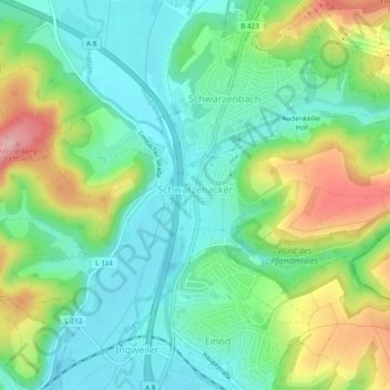
Name: Schwarzenacker topographic map, elevation, terrain.
Average elevation: 879 ft
Minimum elevation: 705 ft
Maximum elevation: 1,230 ft
Make a donation
Gear up for your next adventure:
As an Amazon Associate, this site earns from qualifying purchases at no extra cost to you.
Other topographic maps
Click on a map to view its topography, its elevation and its terrain.
Königsbruch / Jägersburger Wald
Deutschland > Saarland > Saarpfalz-Kreis > Homburg
Average elevation: 843 ft
Schwarzenbach
Deutschland > Saarland > Saarpfalz-Kreis > Homburg
Das im Osten des Saarlandes gelegene Homburg grenzt an die Ausläufer des Pfälzerwaldes. Die westlichen Stadtteile Beeden, Schwarzenbach, Wörschweiler, Schwarzenacker, Einöd und Ingweiler liegen im bzw. am Tal der Blies. Der teilweise verwendete Namenszusatz „(Saar)“ (auch „/Saar“) ist ein Relikt…
Average elevation: 879 ft
Make a donation
Gear up for your next adventure:
As an Amazon Associate, this site earns from qualifying purchases at no extra cost to you.
Schwarzenbach
Deutschland > Saarland > Saarpfalz-Kreis > Homburg
Das im Osten des Saarlandes gelegene Homburg grenzt an die Ausläufer des Pfälzerwaldes. Die westlichen Stadtteile Beeden, Schwarzenbach, Wörschweiler, Schwarzenacker, Einöd und Ingweiler liegen im bzw. am Tal der Blies. Der teilweise verwendete Namenszusatz „(Saar)“ (auch „/Saar“) ist ein Relikt…
Average elevation: 879 ft