Geolocate

Minjee topographic map

Click on the map to display elevation.

About this map

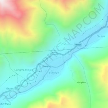
Name: Minjee topographic map, elevation, terrain.

Location: Minjee, Sankoo, Kargil district, Ladakh, India (34.46816 76.07978 34.50816 76.11978)

Average elevation: 10,276 ft

Minimum elevation: 8,914 ft

Maximum elevation: 13,645 ft

Gear up for your next adventure:

🦺Reflective Outdoor Gear - Safety gear for low‑light conditions
🧷Carabiner Set - Durable clips for gear attachment
🌎3D Topographic Globes - Raised relief globes for a tactile understanding of geography
📱Solar Portable Charger - Solar power bank for charging devices off‑grid
Backpacking Tents - Weight-optimized shelters for multi-day topographic surveys

As an Amazon Associate, this site earns from qualifying purchases at no extra cost to you.