
Thank you for supporting this site ❤️
Make a donation
Make a donation
Gear up for your next adventure:
As an Amazon Associate, this site earns from qualifying purchases at no extra cost to you.
Gampel topographic map
Click on the map to display elevation.
Thank you for supporting this site ❤️
Make a donation
Make a donation
Gear up for your next adventure:
As an Amazon Associate, this site earns from qualifying purchases at no extra cost to you.
About this map
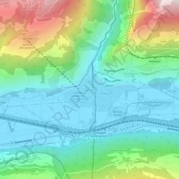
Name: Gampel topographic map, elevation, terrain.
Location: Gampel, Gampel-Bratsch, Leuk, Wallis, 3945, Schweiz (46.29535 7.72300 46.33535 7.76300)
Average elevation: 3,222 ft
Minimum elevation: 2,044 ft
Maximum elevation: 6,355 ft
Thank you for supporting this site ❤️
Make a donation
Make a donation
Gear up for your next adventure:
As an Amazon Associate, this site earns from qualifying purchases at no extra cost to you.