
Make a donation
Gear up for your next adventure:
As an Amazon Associate, this site earns from qualifying purchases at no extra cost to you.
Slocan topographic map
Click on the map to display elevation.
Make a donation
Gear up for your next adventure:
As an Amazon Associate, this site earns from qualifying purchases at no extra cost to you.
About this map
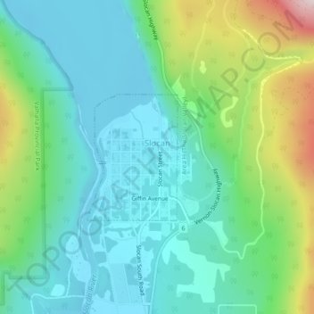
Name: Slocan topographic map, elevation, terrain.
Average elevation: 2,182 ft
Minimum elevation: 1,745 ft
Maximum elevation: 3,445 ft
Make a donation
Gear up for your next adventure:
As an Amazon Associate, this site earns from qualifying purchases at no extra cost to you.
Other topographic maps
Click on a map to view its topography, its elevation and its terrain.
Mount Thor
Canada > British Columbia > Regional District of Central Kootenay > Area K (The Arrow Lakes)
Average elevation: 7,290 ft
Stoney Creek
Canada > British Columbia > Regional District of Central Kootenay > Area K (The Arrow Lakes)
Average elevation: 4,249 ft
Winlaw
Canada > British Columbia > Regional District of Central Kootenay > Area H (The Slocan Valley)
Average elevation: 2,277 ft
Make a donation
Gear up for your next adventure:
As an Amazon Associate, this site earns from qualifying purchases at no extra cost to you.
Kitchener
Canada > British Columbia > Regional District of Central Kootenay > Area B > Kitchener
Average elevation: 3,035 ft