
Make a donation
Gear up for your next adventure:
As an Amazon Associate, this site earns from qualifying purchases at no extra cost to you.
Gutenthal topographic map
Click on the map to display elevation.
Make a donation
Gear up for your next adventure:
As an Amazon Associate, this site earns from qualifying purchases at no extra cost to you.
Gutenthal
Der Ort liegt südwestlich von Morbach an der Hunsrückhöhenstraße. Zu Gutenthal gehört auch der Wohnplatz Auf der Heide. Nachbarorte sind im Nordosten Morbach selbst, sowie die Gemeindeteile Hoxel und Wolzburg im Süden, Odert im Westen und Weiperath im Nordwesten.
Make a donation
Gear up for your next adventure:
As an Amazon Associate, this site earns from qualifying purchases at no extra cost to you.
About this map
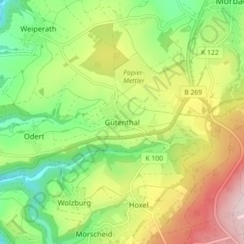
Name: Gutenthal topographic map, elevation, terrain.
Average elevation: 1,604 ft
Minimum elevation: 1,112 ft
Maximum elevation: 2,293 ft
Make a donation
Gear up for your next adventure:
As an Amazon Associate, this site earns from qualifying purchases at no extra cost to you.
Other topographic maps
Click on a map to view its topography, its elevation and its terrain.
Wolzburg
Deutschland > Rheinland-Pfalz > Landkreis Bernkastel-Wittlich > Morbach
Average elevation: 1,831 ft
Hoxel
Deutschland > Rheinland-Pfalz > Landkreis Bernkastel-Wittlich > Morbach
Average elevation: 1,686 ft
Heinzerath
Deutschland > Rheinland-Pfalz > Landkreis Bernkastel-Wittlich > Morbach
Average elevation: 1,627 ft
Gonzerath
Deutschland > Rheinland-Pfalz > Landkreis Bernkastel-Wittlich > Morbach > Gonzerath
Average elevation: 1,654 ft
Make a donation
Gear up for your next adventure:
As an Amazon Associate, this site earns from qualifying purchases at no extra cost to you.