
Make a donation
Gear up for your next adventure:
As an Amazon Associate, this site earns from qualifying purchases at no extra cost to you.
Morannes topographic map
Click on the map to display elevation.
Make a donation
Gear up for your next adventure:
As an Amazon Associate, this site earns from qualifying purchases at no extra cost to you.
Morannes
L'altitude de la commune varie de 17 à 66 mètres, et son territoire s'étend sur près de 41 km2 (4 073 hectares).
Make a donation
Gear up for your next adventure:
As an Amazon Associate, this site earns from qualifying purchases at no extra cost to you.
About this map
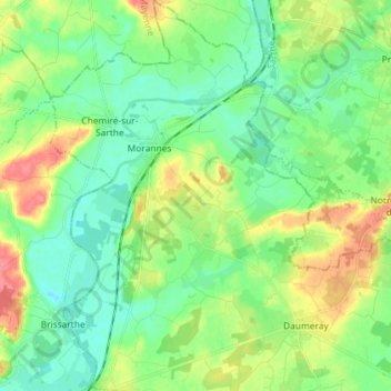
Name: Morannes topographic map, elevation, terrain.
Average elevation: 118 ft
Minimum elevation: 46 ft
Maximum elevation: 262 ft
Make a donation
Gear up for your next adventure:
As an Amazon Associate, this site earns from qualifying purchases at no extra cost to you.
Other topographic maps
Click on a map to view its topography, its elevation and its terrain.
La Pécaudière
France > Pays de la Loire > Maine-et-Loire > Morannes sur Sarthe-Daumeray
Average elevation: 95 ft
Pendu
France > Pays de la Loire > Maine-et-Loire > Morannes sur Sarthe-Daumeray
Average elevation: 98 ft