
Make a donation
Gear up for your next adventure:
As an Amazon Associate, this site earns from qualifying purchases at no extra cost to you.
Becerril topographic map
Click on the map to display elevation.
Make a donation
Gear up for your next adventure:
As an Amazon Associate, this site earns from qualifying purchases at no extra cost to you.
About this map
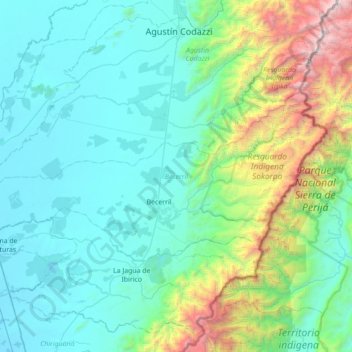
Name: Becerril topographic map, elevation, terrain.
Location: Becerril, Cesar, RAP Caribe, Colombia (9.58701 -73.64483 9.91993 -72.94512)
Average elevation: 2,031 ft
Minimum elevation: 112 ft
Maximum elevation: 11,621 ft
Make a donation
Gear up for your next adventure:
As an Amazon Associate, this site earns from qualifying purchases at no extra cost to you.
Other topographic maps
Click on a map to view its topography, its elevation and its terrain.
La Esperanza
Colombia > Cesar > San Alberto
En 1920, José Juan Tablada, poeta coyoacanense introductor de la poesía japonesa en lengua castellana y Secretario de la Legación de México se asentó durante un par de años en la villa a causa de sus problemas para adecuarse a la altitud de Bogotá, desde La Esperanza comenzó un serio trabajo cultural…
Average elevation: 1,535 ft
Make a donation
Gear up for your next adventure:
As an Amazon Associate, this site earns from qualifying purchases at no extra cost to you.