Geolocate

Tagabaca topographic map

Click on the map to display elevation.

About this map

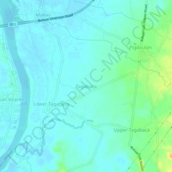
Name: Tagabaca topographic map, elevation, terrain.

Location: Tagabaca, Butuan, Caraga, Philippines (8.88841 125.55180 8.92841 125.59180)

Average elevation: 36 ft

Minimum elevation: 13 ft

Maximum elevation: 121 ft

Gear up for your next adventure:

🌄Hiking Binoculars - Compact binoculars for scenic views and trail spotting
GPS Sports Watch - GPS watch for running, hiking and training
Backpacking Tent - Lightweight and durable tent for multi‑day hikes
📌Outdoor GPS Map App - Apps and devices for digital topographic navigation
🔋Rechargeable Batteries - Power up your outdoor devices

As an Amazon Associate, this site earns from qualifying purchases at no extra cost to you.