
Make a donation
Gear up for your next adventure:
As an Amazon Associate, this site earns from qualifying purchases at no extra cost to you.
Riedlberg topographic map
Click on the map to display elevation.
Make a donation
Gear up for your next adventure:
As an Amazon Associate, this site earns from qualifying purchases at no extra cost to you.
About this map
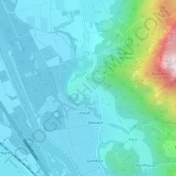
Name: Riedlberg topographic map, elevation, terrain.
Average elevation: 1,883 ft
Minimum elevation: 1,473 ft
Maximum elevation: 4,137 ft
Make a donation
Gear up for your next adventure:
As an Amazon Associate, this site earns from qualifying purchases at no extra cost to you.
Other topographic maps
Click on a map to view its topography, its elevation and its terrain.
Untersulzberg
Deutschland > Bayern > Landkreis Rosenheim > Nußdorf am Inn > Untersulzberg
Average elevation: 2,093 ft
Heuberg
Deutschland > Bayern > Landkreis Rosenheim > Nußdorf am Inn
Am Heuberg gibt es seit 1961 den Steinbruch Nußdorf vom Portland-Zementwerk Rohrdorf. Nach der Genehmigung aus dem Jahr 1961 sollte Kalksteinabbau zum Schutz vor Lärm und Staub sowie zur Erhaltung des Landschaftsbildes hinter einer Schutzwand erfolgen. Bereits nach wenigen Monaten stürzten große Teile der…
Average elevation: 2,841 ft
Make a donation
Gear up for your next adventure:
As an Amazon Associate, this site earns from qualifying purchases at no extra cost to you.