
Make a donation
Gear up for your next adventure:
As an Amazon Associate, this site earns from qualifying purchases at no extra cost to you.
Ratnagiri topographic map
Click on the map to display elevation.
Make a donation
Gear up for your next adventure:
As an Amazon Associate, this site earns from qualifying purchases at no extra cost to you.
Ratnagiri
Ratnagiri is located at 16°59′N 73°18′E / 16.98°N 73.3°E / 16.98; 73.3. It has an average elevation of 11 meters (36 feet). The Sahyadri mountains border Ratnagiri to the east
Make a donation
Gear up for your next adventure:
As an Amazon Associate, this site earns from qualifying purchases at no extra cost to you.
About this map
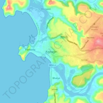
Name: Ratnagiri topographic map, elevation, terrain.
Location: Ratnagiri, Maharashtra, 415612, India (16.95335 73.25544 17.03335 73.33544)
Average elevation: 98 ft
Minimum elevation: -10 ft
Maximum elevation: 446 ft
Make a donation
Gear up for your next adventure:
As an Amazon Associate, this site earns from qualifying purchases at no extra cost to you.
Other topographic maps
Click on a map to view its topography, its elevation and its terrain.