
Make a donation
Gear up for your next adventure:
As an Amazon Associate, this site earns from qualifying purchases at no extra cost to you.
Winnemark topographic map
Click on the map to display elevation.
Make a donation
Gear up for your next adventure:
As an Amazon Associate, this site earns from qualifying purchases at no extra cost to you.
Winnemark
Am östlichen Rand der Gemeinde führt die Bundesstraße 203 auf einem äußerst kurzen Trassenstück durch das Gemeindegebiet. Die Anbindung in die Gemeinde erfolgt über die an der Kreisgrenze befindliche, höhenfrei ausgebaute Anschlussstelle des Nachbarortes Karby über niedriger geordnete Kreisstraßen.
Make a donation
Gear up for your next adventure:
As an Amazon Associate, this site earns from qualifying purchases at no extra cost to you.
About this map
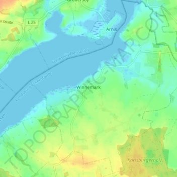
Name: Winnemark topographic map, elevation, terrain.
Average elevation: 33 ft
Minimum elevation: -10 ft
Maximum elevation: 102 ft
Make a donation
Gear up for your next adventure:
As an Amazon Associate, this site earns from qualifying purchases at no extra cost to you.
Other topographic maps
Click on a map to view its topography, its elevation and its terrain.
Ramsdorf
Deutschland > Schleswig-Holstein > Kreis Rendsburg-Eckernförde > Owschlag
Average elevation: 52 ft
Aukrug
Deutschland > Schleswig-Holstein > Kreis Rendsburg-Eckernförde
Die Gemeinde ist ein staatlich anerkannter Erholungsort und liegt im Herzen des 380 km² großen Naturparks Aukrug mit Wiesen und Feldern, Heide, Mooren, Teichen und kleinen Flussläufen. Durch den Abbau von Torf und der anschließenden Herstellung von Torfkohle, die ähnlich wie Holzkohle hergestellt wird,…
Average elevation: 75 ft
Rohrüh
Deutschland > Schleswig-Holstein > Kreis Rendsburg-Eckernförde > Schuby
Average elevation: 30 ft
Make a donation
Gear up for your next adventure:
As an Amazon Associate, this site earns from qualifying purchases at no extra cost to you.
Trömbek
Deutschland > Schleswig-Holstein > Kreis Rendsburg-Eckernförde > Lehmkuhl
Average elevation: 66 ft
Neu-Bülk
Deutschland > Schleswig-Holstein > Kreis Rendsburg-Eckernförde > Rabendorf
Average elevation: 85 ft
Knoop
Deutschland > Schleswig-Holstein > Kreis Rendsburg-Eckernförde > Altenholz
Average elevation: 59 ft
Make a donation
Gear up for your next adventure:
As an Amazon Associate, this site earns from qualifying purchases at no extra cost to you.
Guckelsby
Deutschland > Schleswig-Holstein > Kreis Rendsburg-Eckernförde > Sieseby
Average elevation: 43 ft
Norby
Deutschland > Schleswig-Holstein > Kreis Rendsburg-Eckernförde > Rieseby
Average elevation: 69 ft
Make a donation
Gear up for your next adventure:
As an Amazon Associate, this site earns from qualifying purchases at no extra cost to you.
Osselberg
Deutschland > Schleswig-Holstein > Kreis Rendsburg-Eckernförde > Blumenthal
Average elevation: 128 ft
Aschberg
Deutschland > Schleswig-Holstein > Kreis Rendsburg-Eckernförde > Ascheffel
Average elevation: 128 ft
Make a donation
Gear up for your next adventure:
As an Amazon Associate, this site earns from qualifying purchases at no extra cost to you.
Glüsing
Deutschland > Schleswig-Holstein > Kreis Rendsburg-Eckernförde > Hohenwestedt
Average elevation: 125 ft
Dänisch-Nienhof
Deutschland > Schleswig-Holstein > Kreis Rendsburg-Eckernförde
Average elevation: 56 ft
Make a donation
Gear up for your next adventure:
As an Amazon Associate, this site earns from qualifying purchases at no extra cost to you.
Bössel
Deutschland > Schleswig-Holstein > Kreis Rendsburg-Eckernförde > Nübbel
Average elevation: 20 ft
Make a donation
Gear up for your next adventure:
As an Amazon Associate, this site earns from qualifying purchases at no extra cost to you.