
Ngwempisi topographic map
Interactive map
Click on the map to display elevation.
About this map
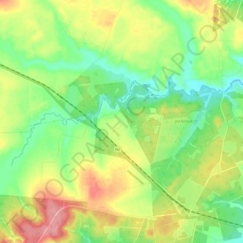
Name: Ngwempisi topographic map, elevation, terrain.
Location: Ngwempisi, Msukaligwa, Gert Sibande, Mpumalanga, RSA (-26.78864 30.35662 -26.75070 30.47387)
Average elevation: 4,705 ft
Minimum elevation: 4,560 ft
Maximum elevation: 4,898 ft
Other topographic maps
Click on a map to view its topography, its elevation and its terrain.
Westoe Dam
RSA > Mpumalanga > Msukaligwa
Westoe Dam, R33, Msukaligwa Ward 15, Msukaligwa, Gert Sibande, Mpumalanga, RSA
Average elevation: 5,131 ft