Geolocate

Agartala topographic map

Click on the map to display elevation.

About this map

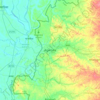
Name: Agartala topographic map, elevation, terrain.

Location: Agartala, Mohanpur, West Tripura, Tripura, 799001, India (23.67124 91.12238 23.99124 91.44238)

Average elevation: 75 ft

Minimum elevation: 3 ft

Maximum elevation: 253 ft

Gear up for your next adventure:

🧤Tactile Hiking Gloves - Keep hands warm while operating GPS and smartphone screens
🥤Water Filter Bottle - All‑in‑one filter bottle for safe hydration
🪵Folding Camp Saw - Compact saw for wood and campsite work
☀️Outdoor Sunscreen - High protection sunscreen for outdoor activities
🚁Photography Drones - Capture stunning aerial views of landforms and topography

As an Amazon Associate, this site earns from qualifying purchases at no extra cost to you.