Geolocate

Echague topographic map

Click on the map to display elevation.

About this map

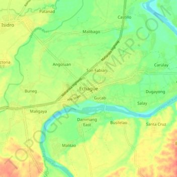
Name: Echague topographic map, elevation, terrain.

Location: Echague, Isabela, Cagayan Valley, 3309, Philippines (16.66536 121.63495 16.74536 121.71495)

Average elevation: 233 ft

Minimum elevation: 157 ft

Maximum elevation: 318 ft

Other topographic maps

Click on a map to view its topography, its elevation and its terrain.

San Guillermo

Philippines > Isabela

Average elevation: 302 ft

Magat Dam

Philippines > Isabela

Average elevation: 577 ft

Gear up for your next adventure:

👟Men's Trail Runners - Lightweight footwear for fast-paced exploration and light hiking
📦Dry Bags Set - Waterproof storage for electronics and clothes
🦺Reflective Outdoor Gear - Safety gear for low‑light conditions
🚑Emergency Bivvies - Heat-reflective sleeping bags for survival situations
🧤Hiking Gloves - Protective gloves for rugged trails

As an Amazon Associate, this site earns from qualifying purchases at no extra cost to you.