Geolocate

Supa topographic map

Click on the map to display elevation.

About this map

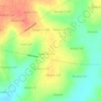
Name: Supa topographic map, elevation, terrain.

Location: Supa, Pallisa, Eastern Region, Uganda (1.14667 33.71333 1.18667 33.75333)

Average elevation: 3,514 ft

Minimum elevation: 3,425 ft

Maximum elevation: 3,606 ft

Gear up for your next adventure:

📶Vehicle Signal Boosters - Improve reception in rural areas while driving to trailheads
👟Men's Trail Runners - Lightweight footwear for fast-paced exploration and light hiking
🥄Camping Utensil Set - Lightweight utensils for outdoor meals
📚USA Hiking Guide Books - Top trail guides and map books
🥾Hiking Shoes - Durable and comfortable shoes for trail hiking

As an Amazon Associate, this site earns from qualifying purchases at no extra cost to you.