
Make a donation
Gear up for your next adventure:
As an Amazon Associate, this site earns from qualifying purchases at no extra cost to you.
Isongo topographic map
Click on the map to display elevation.
Make a donation
Gear up for your next adventure:
As an Amazon Associate, this site earns from qualifying purchases at no extra cost to you.
About this map
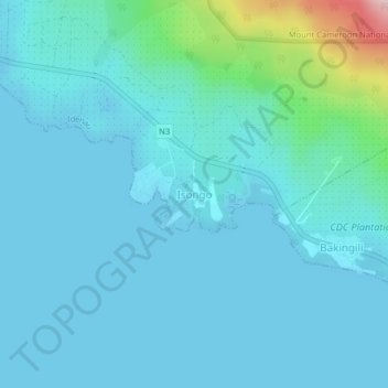
Name: Isongo topographic map, elevation, terrain.
Location: Isongo, Idenau, Fako, Southwest, Cameroon (4.05059 8.99879 4.09059 9.03879)
Average elevation: 102 ft
Minimum elevation: -7 ft
Maximum elevation: 850 ft
Make a donation
Gear up for your next adventure:
As an Amazon Associate, this site earns from qualifying purchases at no extra cost to you.
Other topographic maps
Click on a map to view its topography, its elevation and its terrain.
Buea
Because of its location at the foot of Mount Fako, the climate in Buea tends to be humid, with neighbourhoods at higher elevations enjoying cooler temperatures while lower neighbourhoods experience a hotter climate. Extended periods of rainfall, characterized by incessant drizzle, which can last for weeks, are…
Average elevation: 2,595 ft
Make a donation
Gear up for your next adventure:
As an Amazon Associate, this site earns from qualifying purchases at no extra cost to you.