
Thank you for supporting this site ❤️
Make a donation
Make a donation
Gear up for your next adventure:
As an Amazon Associate, this site earns from qualifying purchases at no extra cost to you.
Canonica topographic map
Click on the map to display elevation.
Thank you for supporting this site ❤️
Make a donation
Make a donation
Gear up for your next adventure:
As an Amazon Associate, this site earns from qualifying purchases at no extra cost to you.
About this map
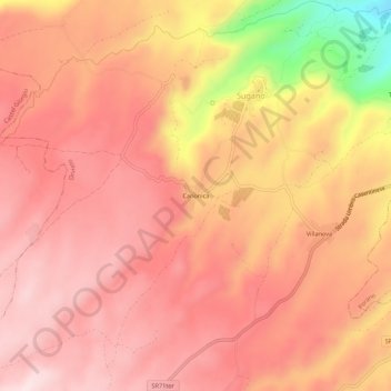
Name: Canonica topographic map, elevation, terrain.
Location: Canonica, Sugano, Orvieto, Terni, Umbria, 05018, Italia (42.68000 12.02882 42.72000 12.06882)
Average elevation: 1,558 ft
Minimum elevation: 682 ft
Maximum elevation: 1,909 ft
Thank you for supporting this site ❤️
Make a donation
Make a donation
Gear up for your next adventure:
As an Amazon Associate, this site earns from qualifying purchases at no extra cost to you.