
Make a donation
Gear up for your next adventure:
As an Amazon Associate, this site earns from qualifying purchases at no extra cost to you.
Provo Peak topographic map
Click on the map to display elevation.
Make a donation
Gear up for your next adventure:
As an Amazon Associate, this site earns from qualifying purchases at no extra cost to you.
Provo Peak
Provo Peak is a mountain peak located in the Wasatch Range and the Uinta National Forest that is located within the city limits of Provo, Utah, United States. The peak has an elevation of 11,068 feet (3,374 m), but a prominence of only 3,442 feet (1,049 m). Although located along the Wasatch Front, it is situated behind (east-southeast) of Y Mountain.
Make a donation
Gear up for your next adventure:
As an Amazon Associate, this site earns from qualifying purchases at no extra cost to you.
About this map
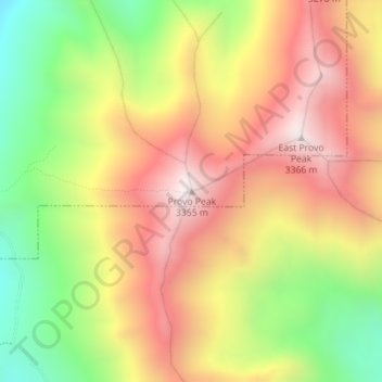
Name: Provo Peak topographic map, elevation, terrain.
Location: Provo Peak, Provo, Utah County, Utah, United States (40.24426 -111.55678 40.24436 -111.55668)
Average elevation: 9,537 ft
Minimum elevation: 7,867 ft
Maximum elevation: 11,010 ft
Make a donation
Gear up for your next adventure:
As an Amazon Associate, this site earns from qualifying purchases at no extra cost to you.