
Thank you for supporting this site ❤️
Make a donation
Make a donation
Gear up for your next adventure:
As an Amazon Associate, this site earns from qualifying purchases at no extra cost to you.
Amet topographic map
Click on the map to display elevation.
Thank you for supporting this site ❤️
Make a donation
Make a donation
Gear up for your next adventure:
As an Amazon Associate, this site earns from qualifying purchases at no extra cost to you.
About this map
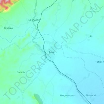
Name: Amet topographic map, elevation, terrain.
Location: Amet, Amet Tehsil, Rajsamand, Rajasthan, 313332, India (25.26125 73.88737 25.34125 73.96737)
Average elevation: 1,969 ft
Minimum elevation: 1,850 ft
Maximum elevation: 2,969 ft
Thank you for supporting this site ❤️
Make a donation
Make a donation
Gear up for your next adventure:
As an Amazon Associate, this site earns from qualifying purchases at no extra cost to you.