
Make a donation
Gear up for your next adventure:
As an Amazon Associate, this site earns from qualifying purchases at no extra cost to you.
Benroth topographic map
Click on the map to display elevation.
Make a donation
Gear up for your next adventure:
As an Amazon Associate, this site earns from qualifying purchases at no extra cost to you.
Benroth
Ein Teilstück des Graf-Engelbert-Weg von geht von Wiehl-Drabenderhöhe – Oberbach – Herftenrath über Nümbrecht-Kurtenbach – Niederbreidenbach – Grunewald – Lindscheid – Benroth – Berkenroth über Waldbröl-Geilenkausen – Bladersbach, am Galgenberg und den „Drei Eichen“ dem Windecker Hochgericht des Mittelalters vorbei, über den Höhenzug Nutscheid über Höhnrath nach Windeck-Schladern (S-Bahn Haltestelle). Streckenlänge 25 km
Make a donation
Gear up for your next adventure:
As an Amazon Associate, this site earns from qualifying purchases at no extra cost to you.
About this map
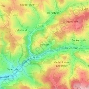
Name: Benroth topographic map, elevation, terrain.
Average elevation: 817 ft
Minimum elevation: 548 ft
Maximum elevation: 1,109 ft
Make a donation
Gear up for your next adventure:
As an Amazon Associate, this site earns from qualifying purchases at no extra cost to you.
Other topographic maps
Click on a map to view its topography, its elevation and its terrain.
Kurpark Nümbrecht
Deutschland > Nordrhein-Westfalen > Oberbergischer Kreis > Nümbrecht > Ödinghausen
Average elevation: 919 ft
Schloss Homburg
Deutschland > Nordrhein-Westfalen > Oberbergischer Kreis > Nümbrecht > Homburg-Bröl > Unter der Hardt
Average elevation: 843 ft
Guxmühlen
Deutschland > Nordrhein-Westfalen > Oberbergischer Kreis > Nümbrecht > Marienberghausen
Auf der Hardt | Abbenroth | Ahebruch | Ahlbusch | Alsbach | Altennümbrecht | Bierenbachtal | Breunfeld | Benroth | Berkenroth | Birkenbach | Breitewiese | Brünglinghausen | Bruch | Büschhof | Buch | Distelkamp | Drinsahl | Elsenroth | Erlinghausen | Friedenthal | Gaderoth | Gerhardsiefen | Geringhausen |…
Average elevation: 814 ft