Geolocate

Montescheno topographic map

Click on the map to display elevation.

About this map

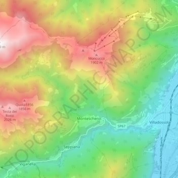
Name: Montescheno topographic map, elevation, terrain.

Location: Montescheno, Verbano-Cusio-Ossola, Piedmont, 28843, Italy (46.05398 8.14672 46.10225 8.23571)

Average elevation: 3,402 ft

Minimum elevation: 732 ft

Maximum elevation: 7,287 ft

Gear up for your next adventure:

🪶Survival Guide Book - Expert advice for emergency preparedness
🕶️GPS Smartphone Mount - Secure mount for phone navigation
🚁Photography Drones - Capture stunning aerial views of landforms and topography
📱Solar Portable Charger - Solar power bank for charging devices off‑grid
🧭Orienteering Set - Complete compass and map reading kit

As an Amazon Associate, this site earns from qualifying purchases at no extra cost to you.