Geolocate

Sardis topographic map

Click on the map to display elevation.

About this map

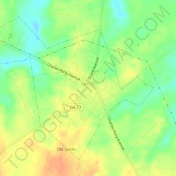
Name: Sardis topographic map, elevation, terrain.

Location: Sardis, Burke County, Georgia, United States (32.96121 -81.78144 32.98723 -81.74349)

Average elevation: 226 ft

Minimum elevation: 157 ft

Maximum elevation: 289 ft

Burke County trails, hiking, mountain biking, running and outdoor activities

Other topographic maps

Click on a map to view its topography, its elevation and its terrain.

Watkins Pond

United States > Georgia > Burke County

Average elevation: 256 ft

Gear up for your next adventure:

🛡️Insect Repellent - Protection against bugs during outdoor activities
🌡️Handheld Weather Meters - Measure wind, temp, and pressure for safe mountain travel
🚁Photography Drones - Capture stunning aerial views of landforms and topography
📡GPS Antenna Upgrade - Enhance GPS reception in remote terrain
📦Gear Storage Bags - Organize and protect outdoor equipment

As an Amazon Associate, this site earns from qualifying purchases at no extra cost to you.