
Make a donation
Gear up for your next adventure:
As an Amazon Associate, this site earns from qualifying purchases at no extra cost to you.
Oberhausen topographic map
Click on the map to display elevation.
Make a donation
Gear up for your next adventure:
As an Amazon Associate, this site earns from qualifying purchases at no extra cost to you.
About this map
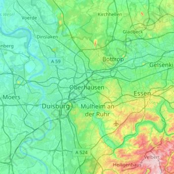
Name: Oberhausen topographic map, elevation, terrain.
Average elevation: 194 ft
Minimum elevation: 39 ft
Maximum elevation: 889 ft
Make a donation
Gear up for your next adventure:
As an Amazon Associate, this site earns from qualifying purchases at no extra cost to you.
Other topographic maps
Click on a map to view its topography, its elevation and its terrain.
Make a donation
Gear up for your next adventure:
As an Amazon Associate, this site earns from qualifying purchases at no extra cost to you.
Alstaden
Deutschland > Nordrhein-Westfalen > Oberhausen
Alstadens Lage an der Ruhr und seine Topographie haben in der vorindustriellen Phase die Entwicklung des Dorfes geprägt: Nächst dem Fluss befanden sich die Ruhrauen, ein fruchtbares Überschwemmungsgebiet, das sich zur Viehzucht eignete und zu einer Niederterrasse anstieg, die hochwasserfrei war und aus…
Average elevation: 108 ft