Geolocate

Lembang topographic map

Click on the map to display elevation.

About this map

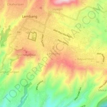
Name: Lembang topographic map, elevation, terrain.

Location: Lembang, West Bandung, West Java, Java, 40391, Indonesia (-6.84504 107.60610 -6.80504 107.64610)

Average elevation: 3,901 ft

Minimum elevation: 3,146 ft

Maximum elevation: 4,596 ft

Other topographic maps

Click on a map to view its topography, its elevation and its terrain.

Sungai Cikapundung

Indonesia > West Java > West Bandung > Suntenjaya

Average elevation: 2,657 ft

Bosscha Observatory

Indonesia > West Java > West Bandung > Lembang

Average elevation: 3,953 ft

Situ Ciburuy

Indonesia > West Java > West Bandung > Ciburuy

Average elevation: 2,349 ft

Gear up for your next adventure:

📶Satellite Messenger - Communication device off‑grid
📱Solar Portable Charger - Solar power bank for charging devices off‑grid
🧥Men's Rain Shells - Premium waterproof and breathable jackets for mountain weather
🗃️Trail First Aid Kit - Essential kit for outdoor injuries and emergencies
Backpacking Tent - Lightweight and durable tent for multi‑day hikes

As an Amazon Associate, this site earns from qualifying purchases at no extra cost to you.