
Clear Lake topographic map
Interactive map
Click on the map to display elevation.
About this map
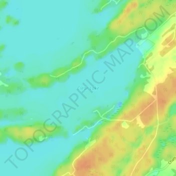
Name: Clear Lake topographic map, elevation, terrain.
Average elevation: 423 ft
Minimum elevation: 381 ft
Maximum elevation: 492 ft
Other topographic maps
Click on a map to view its topography, its elevation and its terrain.
Elgin
Canada > Ontario > Rideau Lakes > Elgin
Elgin, Rideau Lakes, Leeds and Grenville Counties, Eastern Ontario, Ontario, K0G 1E0, Canada
Average elevation: 453 ft
Big Island
Canada > Ontario > Rideau Lakes
Big Island, Rideau Lakes, Leeds and Grenville Counties, Eastern Ontario, Ontario, Canada
Average elevation: 404 ft
Sand Lake
Canada > Ontario > Rideau Lakes
Sand Lake, Delong Road, Rideau Lakes, Leeds and Grenville Counties, Eastern Ontario, Ontario, K0G 1E0, Canada
Average elevation: 407 ft