
Make a donation
Gear up for your next adventure:
As an Amazon Associate, this site earns from qualifying purchases at no extra cost to you.
Zayed City topographic map
Click on the map to display elevation.
Make a donation
Gear up for your next adventure:
As an Amazon Associate, this site earns from qualifying purchases at no extra cost to you.
About this map
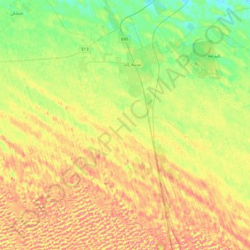
Name: Zayed City topographic map, elevation, terrain.
Average elevation: 423 ft
Minimum elevation: 282 ft
Maximum elevation: 600 ft
Make a donation
Gear up for your next adventure:
As an Amazon Associate, this site earns from qualifying purchases at no extra cost to you.
Other topographic maps
Click on a map to view its topography, its elevation and its terrain.
Sila
United Arab Emirates > Abu Dhabi Emirate > Al Dhafrah Region > Al Sila'
Average elevation: 128 ft
Zarkoh Island
United Arab Emirates > Abu Dhabi Emirate > Al Dhafrah Region > Zirku Island
Average elevation: 33 ft
Make a donation
Gear up for your next adventure:
As an Amazon Associate, this site earns from qualifying purchases at no extra cost to you.
Liwa
United Arab Emirates > Abu Dhabi Emirate > Al Dhafrah Region > Mzeerʻah
Average elevation: 443 ft
Liwa
United Arab Emirates > Abu Dhabi Emirate > Al Dhafrah Region > Mzeerʻah
Average elevation: 443 ft
Make a donation
Gear up for your next adventure:
As an Amazon Associate, this site earns from qualifying purchases at no extra cost to you.
Al Ruwais
United Arab Emirates > Abu Dhabi Emirate > Al Dhafrah Region > Al Ruways Industrial City
Average elevation: 52 ft