
Make a donation
Gear up for your next adventure:
As an Amazon Associate, this site earns from qualifying purchases at no extra cost to you.
Farnsberg topographic map
Click on the map to display elevation.
Make a donation
Gear up for your next adventure:
As an Amazon Associate, this site earns from qualifying purchases at no extra cost to you.
About this map
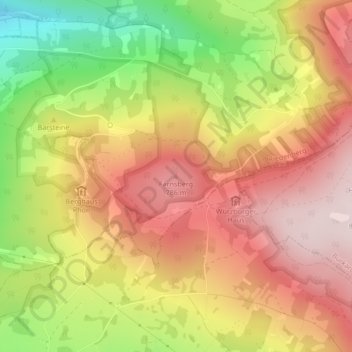
Name: Farnsberg topographic map, elevation, terrain.
Average elevation: 2,172 ft
Minimum elevation: 1,430 ft
Maximum elevation: 2,723 ft
Make a donation
Gear up for your next adventure:
As an Amazon Associate, this site earns from qualifying purchases at no extra cost to you.
Other topographic maps
Click on a map to view its topography, its elevation and its terrain.
Schwarze Berge
Deutschland > Bayern > Landkreis Bad Kissingen > Riedenberg
Feuerbachmoor | Grundwiese (Hornwiese) | Haarberg | Kernzonen im bayerischen Teil des Biosphärenreservats Rhön | Naturwaldinsel Buchwald | Naturwaldreservat Dachsbau | Naturwaldreservat Dianensruh | Reiterswiesener Höhe-Häuserlohwäldchen | Schachblumenwiesen bei Zeitlofs | Schwarze Berge | Sodenberg-Gans…
Average elevation: 1,886 ft