
Make a donation
Gear up for your next adventure:
As an Amazon Associate, this site earns from qualifying purchases at no extra cost to you.
Templeglantine topographic map
Click on the map to display elevation.
Make a donation
Gear up for your next adventure:
As an Amazon Associate, this site earns from qualifying purchases at no extra cost to you.
About this map
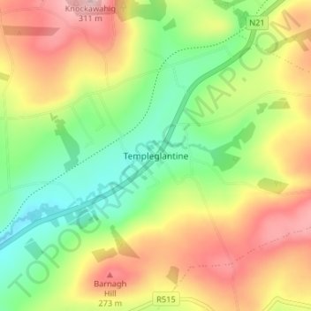
Name: Templeglantine topographic map, elevation, terrain.
Average elevation: 620 ft
Minimum elevation: 308 ft
Maximum elevation: 997 ft
Make a donation
Gear up for your next adventure:
As an Amazon Associate, this site earns from qualifying purchases at no extra cost to you.
Other topographic maps
Click on a map to view its topography, its elevation and its terrain.
Ahadagh
Ireland > County Limerick > The Municipal District of Newcastle West
Average elevation: 315 ft
Newcastle West
Ireland > County Limerick > The Municipal District of Newcastle West
Average elevation: 190 ft
Cloonsherick
Ireland > County Limerick > The Municipal District of Newcastle West
Average elevation: 213 ft
Make a donation
Gear up for your next adventure:
As an Amazon Associate, this site earns from qualifying purchases at no extra cost to you.
Newcastle
Ireland > County Limerick > The Municipal District of Newcastle West
Average elevation: 302 ft
Churchtown
Ireland > County Limerick > The Municipal District of Newcastle West
Average elevation: 217 ft
Cappanihane
Ireland > County Limerick > The Municipal District of Newcastle West
Average elevation: 335 ft
Make a donation
Gear up for your next adventure:
As an Amazon Associate, this site earns from qualifying purchases at no extra cost to you.
Killard
Ireland > County Limerick > The Municipal District of Newcastle West
Average elevation: 200 ft
Coolacokery
Ireland > County Limerick > The Municipal District of Newcastle West
Average elevation: 171 ft
Crataloe West
Ireland > County Limerick > The Municipal District of Newcastle West
Average elevation: 502 ft
Crataloe East
Ireland > County Limerick > The Municipal District of Newcastle West
Average elevation: 604 ft
Make a donation
Gear up for your next adventure:
As an Amazon Associate, this site earns from qualifying purchases at no extra cost to you.
Ballaghbehy
Ireland > County Limerick > The Municipal District of Newcastle West
Average elevation: 443 ft
Caheragh
Ireland > County Limerick > The Municipal District of Newcastle West
Average elevation: 85 ft
Ballyduhig
Ireland > County Limerick > The Municipal District of Newcastle West
Average elevation: 374 ft
Make a donation
Gear up for your next adventure:
As an Amazon Associate, this site earns from qualifying purchases at no extra cost to you.