
Castaunouze topographic map
Interactive map
Click on the map to display elevation.
About this map
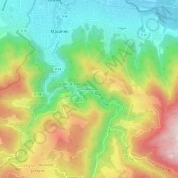
Name: Castaunouze topographic map, elevation, terrain.
Average elevation: 1,512 ft
Minimum elevation: 738 ft
Maximum elevation: 2,628 ft
Other topographic maps
Click on a map to view its topography, its elevation and its terrain.
Le Moulin à Papier
France > Occitanie > Tarn > Mazamet > Hautpoul > Le Moulin à Papier
Le Moulin à Papier, Hautpoul, Mazamet, Castres, Tarn, Occitanie, France métropolitaine, 81200, France
Average elevation: 1,476 ft