
Make a donation
Gear up for your next adventure:
As an Amazon Associate, this site earns from qualifying purchases at no extra cost to you.
Dushanbe topographic map
Click on the map to display elevation.
Make a donation
Gear up for your next adventure:
As an Amazon Associate, this site earns from qualifying purchases at no extra cost to you.
Dushanbe
Dushanbe is the capital and largest city of Tajikistan. As of March 2024, Dushanbe had a population of 1,564,700, with this population being largely Tajik. Until 1929, the city was known in Russian as Dyushambe, and from 1929 to 1961 as Stalinabad, after Joseph Stalin. Dushanbe is located in the Gissar Valley, bounded by the Gissar Range in the north and east and the Babatag, Aktau, Rangontau and Karatau mountains in the south, and has an elevation of 750–930 m. The city is divided into four districts: Ismail Samani, Avicenna, Ferdowsi, and Shah Mansur.
Make a donation
Gear up for your next adventure:
As an Amazon Associate, this site earns from qualifying purchases at no extra cost to you.
About this map
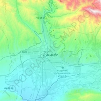
Name: Dushanbe topographic map, elevation, terrain.
Location: Dushanbe, Tajikistan (38.46448 68.68883 38.70684 68.88694)
Average elevation: 3,389 ft
Minimum elevation: 2,313 ft
Maximum elevation: 8,484 ft
Make a donation
Gear up for your next adventure:
As an Amazon Associate, this site earns from qualifying purchases at no extra cost to you.
Other topographic maps
Click on a map to view its topography, its elevation and its terrain.
Khorugh
Tajikistan > Gorno-Badakhshan Autonomous Region > Shughnon District
Khorog is the locality of highest altitude where bandy has been played.
Average elevation: 8,648 ft
Make a donation
Gear up for your next adventure:
As an Amazon Associate, this site earns from qualifying purchases at no extra cost to you.
Ismoil Somoni
Tajikistan > Gorno-Badakhshan Autonomous Region > Murghob District
In 1928, the long-term Tajik-Pamir expedition of the Academy of Sciences of the USSR began to operate, which began with the Soviet-German expedition with the participation of Willi Rickmers. As a result of topographic survey, it was found that one of the peaks visible in the west of the Fedchenko glaciers…
Average elevation: 21,503 ft
Pamir Mountains
Tajikistan > Gorno-Badakhshan Autonomous Region > Murghob District
Average elevation: 20,850 ft
Make a donation
Gear up for your next adventure:
As an Amazon Associate, this site earns from qualifying purchases at no extra cost to you.
Pamir Mountains
Tajikistan > Gorno-Badakhshan Autonomous Region > Murghob District
Average elevation: 20,850 ft
Independence Peak
Tajikistan > Gorno-Badakhshan Autonomous Region > Rushon District
Average elevation: 20,919 ft
Pamir Mountains
Tajikistan > Gorno-Badakhshan Autonomous Region > Murghob District
Average elevation: 20,850 ft
Make a donation
Gear up for your next adventure:
As an Amazon Associate, this site earns from qualifying purchases at no extra cost to you.
Bulunkul
Tajikistan > Gorno-Badakhshan Autonomous Region > Murghob District > Bulunkul
Average elevation: 12,346 ft
Bibi Fatima
Tajikistan > Gorno-Badakhshan Autonomous Region > Ishkoshim District > Yamchun
Average elevation: 11,257 ft
Make a donation
Gear up for your next adventure:
As an Amazon Associate, this site earns from qualifying purchases at no extra cost to you.
Jizev Valley
Tajikistan > Gorno-Badakhshan Autonomous Region > Rushon District
Average elevation: 9,672 ft
Ismoil Somoni
Tajikistan > Gorno-Badakhshan Autonomous Region > Murghob District
In 1928, the long-term Tajik-Pamir expedition of the Academy of Sciences of the USSR began to operate, which began with the Soviet-German expedition with the participation of Willi Rickmers. As a result of topographic survey, it was found that one of the peaks visible in the west of the Fedchenko glaciers…
Average elevation: 21,503 ft
Make a donation
Gear up for your next adventure:
As an Amazon Associate, this site earns from qualifying purchases at no extra cost to you.
Pamir Mountains
Tajikistan > Gorno-Badakhshan Autonomous Region > Murghob District
Average elevation: 20,850 ft
Pamir Mountains
Tajikistan > Gorno-Badakhshan Autonomous Region > Murghob District
Average elevation: 20,850 ft
Make a donation
Gear up for your next adventure:
As an Amazon Associate, this site earns from qualifying purchases at no extra cost to you.