
Make a donation
Gear up for your next adventure:
As an Amazon Associate, this site earns from qualifying purchases at no extra cost to you.
Meulebeke topographic map
Click on the map to display elevation.
Make a donation
Gear up for your next adventure:
As an Amazon Associate, this site earns from qualifying purchases at no extra cost to you.
Meulebeke
Meulebeke ligt in Zandlemig Vlaanderen op een uitloper van het Plateau van Tielt. In het zuiden vindt men de vallei van de Mandel. De hoogte bedraagt 14-37 meter met het hoogste punt in de omgeving van De Paanders waar zich een kleine heuvelrug bevindt.
Make a donation
Gear up for your next adventure:
As an Amazon Associate, this site earns from qualifying purchases at no extra cost to you.
About this map
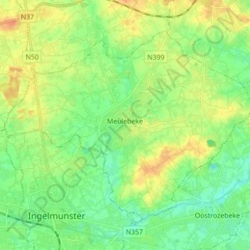
Name: Meulebeke topographic map, elevation, terrain.
Location: Meulebeke, Tielt, West-Vlaanderen, 8760, België (50.91912 3.22909 50.97803 3.35269)
Average elevation: 66 ft
Minimum elevation: 16 ft
Maximum elevation: 131 ft
Make a donation
Gear up for your next adventure:
As an Amazon Associate, this site earns from qualifying purchases at no extra cost to you.
Other topographic maps
Click on a map to view its topography, its elevation and its terrain.
Make a donation
Gear up for your next adventure:
As an Amazon Associate, this site earns from qualifying purchases at no extra cost to you.