
Make a donation
Gear up for your next adventure:
As an Amazon Associate, this site earns from qualifying purchases at no extra cost to you.
Ludlow topographic map
Click on the map to display elevation.
Make a donation
Gear up for your next adventure:
As an Amazon Associate, this site earns from qualifying purchases at no extra cost to you.
Ludlow
During the 12th century, the planned town of Ludlow was formed, in stages, the town providing a useful source of income for successive Marcher Lords, based on rents, fines, and tolls. They developed the town on a regular grid pattern, although this was adapted somewhat to match the local topography, from the late 11th century through the 12th century. The first laid street was along the ridge of the hilltop, what is now Castle Square, High Street and King Street. This formed a wide market place (later in-filled by buildings in places) running from the castle gates east across to St Laurence's and the Bull Ring, itself located on the ancient north–south road, now called Corve Street to the north and Old Street to the south. The wide Mill and Broad Streets were added later, as part of a southern grid plan of streets and burgage plots filling the area bounded by Dinham, the new High Street market, Old Street and the Teme to the south. Originally, Old Street ran down to a ford which took the ancient route south across to Ludford. A bridge was constructed (possibly by Josce de Dinan) at the foot of Broad Street, upstream of the ford, which then replaced the ford; its 15th-century replacement is the present-day Ludford Bridge.
Make a donation
Gear up for your next adventure:
As an Amazon Associate, this site earns from qualifying purchases at no extra cost to you.
About this map
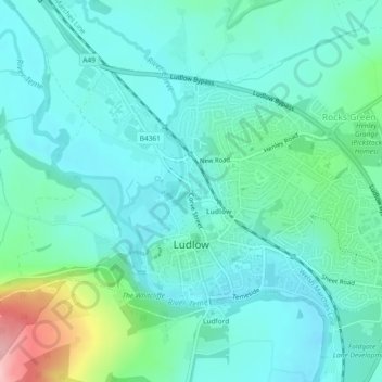
Name: Ludlow topographic map, elevation, terrain.
Location: Ludlow, Shropshire, England, United Kingdom (52.36254 -2.74025 52.38117 -2.69417)
Average elevation: 354 ft
Minimum elevation: 236 ft
Maximum elevation: 833 ft
Make a donation
Gear up for your next adventure:
As an Amazon Associate, this site earns from qualifying purchases at no extra cost to you.
Other topographic maps
Click on a map to view its topography, its elevation and its terrain.
Make a donation
Gear up for your next adventure:
As an Amazon Associate, this site earns from qualifying purchases at no extra cost to you.