
Lico topographic map
Interactive map
Click on the map to display elevation.
About this map
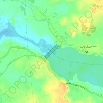
Name: Lico topographic map, elevation, terrain.
Average elevation: 79 ft
Minimum elevation: 30 ft
Maximum elevation: 135 ft
Other topographic maps
Click on a map to view its topography, its elevation and its terrain.
Pulong Bayabas
Philippines > Bulacan > San Rafael
Pulong Bayabas, San Rafael, Bulacan, Central Luzon, 3008, Philippines
Average elevation: 39 ft
Cruz na Daan
Philippines > Bulacan > San Rafael > Cruz na Daan
Cruz na Daan, San Rafael, Bulacan, Central Luzon, 3008, Philippines
Average elevation: 62 ft
Dagat-dagatan
Philippines > Bulacan > San Rafael > Dagat-dagatan
Dagat-dagatan, San Rafael, Bulacan, Central Luzon, 3008, Philippines
Average elevation: 46 ft
Lico
Philippines > Bulacan > San Rafael > Lico
Lico, San Rafael, Bulacan, Central Luzon, 3007, Philippines
Average elevation: 85 ft
Mabalas-balas
Philippines > Bulacan > San Rafael
Mabalas-balas, San Rafael, Bulacan, Central Luzon, 3008, Philippines
Average elevation: 75 ft