
Thank you for supporting this site ❤️
Make a donation
Make a donation
Gear up for your next adventure:
As an Amazon Associate, this site earns from qualifying purchases at no extra cost to you.
Djerma topographic map
Click on the map to display elevation.
Thank you for supporting this site ❤️
Make a donation
Make a donation
Gear up for your next adventure:
As an Amazon Associate, this site earns from qualifying purchases at no extra cost to you.
About this map
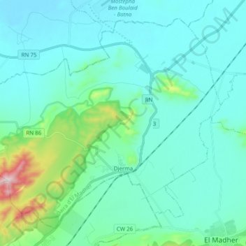
Name: Djerma topographic map, elevation, terrain.
Location: Djerma, El Madher district, Batna, Algeria (35.63161 6.21717 35.73766 6.37024)
Average elevation: 2,992 ft
Minimum elevation: 2,628 ft
Maximum elevation: 4,921 ft
Thank you for supporting this site ❤️
Make a donation
Make a donation
Gear up for your next adventure:
As an Amazon Associate, this site earns from qualifying purchases at no extra cost to you.
Other topographic maps
Click on a map to view its topography, its elevation and its terrain.
ذراع بولطيف ⵖⵉⵍ ⵏ ⴱⵓⵍⵟⵉⴼ
Algeria > Batna > El Madher district > Aïn Yagout
Average elevation: 2,638 ft