
Make a donation
Gear up for your next adventure:
As an Amazon Associate, this site earns from qualifying purchases at no extra cost to you.
Fresno del Río topographic map
Click on the map to display elevation.
Make a donation
Gear up for your next adventure:
As an Amazon Associate, this site earns from qualifying purchases at no extra cost to you.
Fresno del Río
Fresno del Río es una localidad del municipio cántabro de Campoo de Enmedio (España). Cuenta con una población de 150 habitantes, a uno de enero del año 2021, según el INE. Se encuentra a una altitud de 907 m s. n. m. Dista 5,5 kilómetros de la capital municipal, Matamorosa.
Make a donation
Gear up for your next adventure:
As an Amazon Associate, this site earns from qualifying purchases at no extra cost to you.
About this map
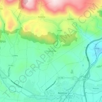
Name: Fresno del Río topographic map, elevation, terrain.
Location: Fresno del Río, Campoo de Enmedio, Cantabria, 39212, España (42.99751 -4.16389 43.03751 -4.12389)
Average elevation: 3,094 ft
Minimum elevation: 2,582 ft
Maximum elevation: 4,157 ft
Make a donation
Gear up for your next adventure:
As an Amazon Associate, this site earns from qualifying purchases at no extra cost to you.