
Coronado topographic map
Interactive map
Click on the map to display elevation.
About this map
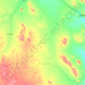
Name: Coronado topographic map, elevation, terrain.
Location: Coronado, Chihuahua, México (26.41931 -105.44218 26.92436 -104.70645)
Average elevation: 5,108 ft
Minimum elevation: 4,367 ft
Maximum elevation: 6,788 ft
Other topographic maps
Click on a map to view its topography, its elevation and its terrain.
Las Carpas
Las Carpas, Madera, Chihuahua, México
Average elevation: 7,566 ft
Santa Rosalia
México > Chihuahua > Matamoros
Santa Rosalia, Matamoros, Chihuahua, México
Average elevation: 5,561 ft
El Sombrero
México > Chihuahua > Hidalgo del Parral > Hidalgo del Parral
El Sombrero, Hidalgo del Parral, Chihuahua, 33896, México
Average elevation: 6,063 ft
Cuauhtémoc
México > Chihuahua > Cuauhtémoc
Cuauhtémoc, Chihuahua, 31500, México
Average elevation: 6,801 ft
Agua Blanca
Agua Blanca, Guadalupe y Calvo, Chihuahua, México
Average elevation: 7,963 ft
Hidalgo del Parral
México > Chihuahua > Hidalgo del Parral
Hidalgo del Parral, Chihuahua, 33834, México
Average elevation: 5,922 ft