
Make a donation
Gear up for your next adventure:
As an Amazon Associate, this site earns from qualifying purchases at no extra cost to you.
Seegräben topographic map
Click on the map to display elevation.
Make a donation
Gear up for your next adventure:
As an Amazon Associate, this site earns from qualifying purchases at no extra cost to you.
Seegräben
Die Topographie ist geprägt durch die Moränen des Linthgletschers, welcher sich während der letzten Eiszeit über das Gebiet erstreckte. Der Aabach durchfliesst ein Tal, an dessen steilen Flanken sich die typische Nagelfluh (Aathalschotter) zeigt. Darin finden sich zahlreiche kleinere und grössere Grotten. Die grösste davon, die sogenannte Franzosenhöhle, ist ca. 24 Meter lang und bis zu 2 Meter hoch. Koord. 699'803/244'000.
Make a donation
Gear up for your next adventure:
As an Amazon Associate, this site earns from qualifying purchases at no extra cost to you.
About this map
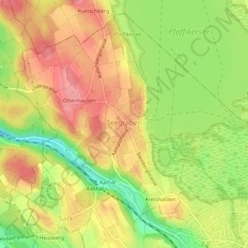
Name: Seegräben topographic map, elevation, terrain.
Location: Seegräben, Bezirk Hinwil, Zürich, 8607, Schweiz (47.32990 8.75332 47.35400 8.78169)
Average elevation: 1,788 ft
Minimum elevation: 1,617 ft
Maximum elevation: 1,913 ft
Make a donation
Gear up for your next adventure:
As an Amazon Associate, this site earns from qualifying purchases at no extra cost to you.
Other topographic maps
Click on a map to view its topography, its elevation and its terrain.
Make a donation
Gear up for your next adventure:
As an Amazon Associate, this site earns from qualifying purchases at no extra cost to you.
Bachtel
Schweiz > Zürich > Bezirk Hinwil > Hinwil
Südöstlich, unterhalb des Gipfels, liegt auf ca. 955 Meter Höhe der Bachtelspalt . Es handelt sich um eine Spalte, die 1939 beim Abrutschen eines NagelfluhKopfes entstand. Sie ist begehbar, aber sehr eng.
Average elevation: 2,848 ft