
Thank you for supporting this site ❤️
Make a donation
Make a donation
Gear up for your next adventure:
As an Amazon Associate, this site earns from qualifying purchases at no extra cost to you.
Frankenbach topographic map
Click on the map to display elevation.
Thank you for supporting this site ❤️
Make a donation
Make a donation
Gear up for your next adventure:
As an Amazon Associate, this site earns from qualifying purchases at no extra cost to you.
About this map
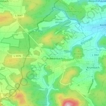
Name: Frankenbach topographic map, elevation, terrain.
Location: Frankenbach, Biebertal, Landkreis Gießen, Hessen, Deutschland (50.65055 8.54422 50.69910 8.59356)
Average elevation: 981 ft
Minimum elevation: 692 ft
Maximum elevation: 1,640 ft
Thank you for supporting this site ❤️
Make a donation
Make a donation
Gear up for your next adventure:
As an Amazon Associate, this site earns from qualifying purchases at no extra cost to you.