
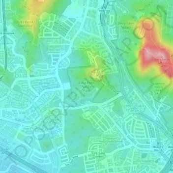
Bukit Batok Nature Park topographic map
Interactive map
Click on the map to display elevation.
About this map
Name: Bukit Batok Nature Park topographic map, elevation, terrain.
Average elevation: 148 ft
Minimum elevation: 16 ft
Maximum elevation: 551 ft
Other topographic maps
Click on a map to view its topography, its elevation and its terrain.
Kent Ridge Park
Kent Ridge Park, Alexandra, Southwest, Singapore
Average elevation: 69 ft
Sungei Buloh Wetland Reserve
Singapore > Southwest > Singapore
Sungei Buloh Wetland Reserve, Singapore, Southwest, 718925, Singapore
Average elevation: 20 ft