
HortPark topographic map
Interactive map
Click on the map to display elevation.
About this map
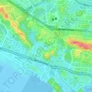
Name: HortPark topographic map, elevation, terrain.
Location: HortPark, Alexandra, Southwest, 119578, Singapore (1.27780 103.79602 1.28058 103.80296)
Average elevation: 69 ft
Minimum elevation: -3 ft
Maximum elevation: 256 ft
Other topographic maps
Click on a map to view its topography, its elevation and its terrain.
Bukit Batok Nature Park
Bukit Batok Nature Park, Bukit Batok East Avenue 6, Bukit Batok, Southwest, 659761, Singapore
Average elevation: 148 ft
Kent Ridge Park
Kent Ridge Park, Alexandra, Southwest, Singapore
Average elevation: 69 ft
Sungei Buloh Wetland Reserve
Singapore > Southwest > Singapore
Sungei Buloh Wetland Reserve, Singapore, Southwest, 718925, Singapore
Average elevation: 20 ft