Geolocate

Cipageran topographic map

Click on the map to display elevation.

About this map

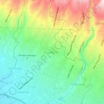
Name: Cipageran topographic map, elevation, terrain.

Location: Cipageran, Cimahi, West Java, Java, 40511, Indonesia (-6.87242 107.53044 -6.83242 107.57044)

Average elevation: 2,848 ft

Minimum elevation: 2,421 ft

Maximum elevation: 3,576 ft

Other topographic maps

Click on a map to view its topography, its elevation and its terrain.

Cimahi

Indonesia > West Java > Cimahi > Baros

Average elevation: 2,346 ft

Gear up for your next adventure:

🪶Wildlife Field Guides - Learn animal tracking and species ID
🌐World Map Poster - Decorative world maps with topographic info
🛠️Backpacking Tool Kit - Essential toolkit for outdoor repairs
📷Action Cameras - Rugged cameras to document your journeys across rugged terrain
🪑Ultralight Camp Chairs - Portable seating for resting after a long day of mapping

As an Amazon Associate, this site earns from qualifying purchases at no extra cost to you.