
Langenthal topographic map
Interactive map
Click on the map to display elevation.
About this map
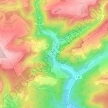
Name: Langenthal topographic map, elevation, terrain.
Average elevation: 1,047 ft
Minimum elevation: 623 ft
Maximum elevation: 1,398 ft
Other topographic maps
Click on a map to view its topography, its elevation and its terrain.
Bärweiler
Germany > Rhineland-Palatinate > Landkreis Bad Kreuznach
Bärweiler, Nahe-Glan, Landkreis Bad Kreuznach, Rhineland-Palatinate, Germany
Average elevation: 1,073 ft
Rüdesheim
Germany > Rhineland-Palatinate > Landkreis Bad Kreuznach
Rüdesheim, Landkreis Bad Kreuznach, Rhineland-Palatinate, 55593, Germany
Average elevation: 541 ft
Rheingrafenstein
Germany > Rhineland-Palatinate > Landkreis Bad Kreuznach > Bad Kreuznach
Rheingrafenstein, Bad Kreuznach, Landkreis Bad Kreuznach, Rhineland-Palatinate, 55583, Germany
Average elevation: 715 ft