
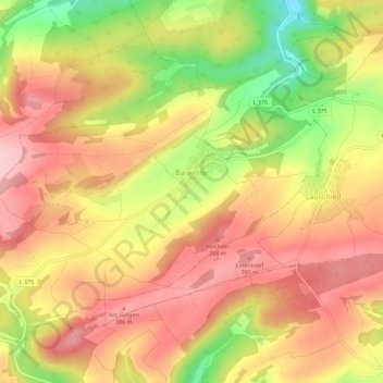
Bärweiler topographic map
Interactive map
Click on the map to display elevation.
About this map
Name: Bärweiler topographic map, elevation, terrain.
Average elevation: 1,073 ft
Minimum elevation: 682 ft
Maximum elevation: 1,325 ft
Bärweiler lies in picturesque hilly land between Bad Sobernheim and Meisenheim. The residential community characterized by agriculture has a municipal area measuring 611 ha. The municipality lies 10 km from Bad Sobernheim, 13 km from Kirn, 10 km from Meisenheim and roughly 30 km from the district seat, Bad Kreuznach. The village, which lies south of the Nahe, belongs to the northernmost part of the Saar-Nahe Uplands and Hills, more precisely to the Sien-Lauschied Ridge in the Meisenheim Uplands (Glan-Alsenz Mountains). Because of the lively breaking-up of the landscape into scattered, wooded hillocks and ridges, hollows and open plateau remnants, the countryside is also described as “humpy land”. The highest elevation in the municipality reaches 393.0 m above sea level, while the lowest point is 225.3 m above sea level.
Other topographic maps
Click on a map to view its topography, its elevation and its terrain.
Langenthal
Germany > Rhineland-Palatinate > Landkreis Bad Kreuznach
Langenthal, Nahe-Glan, Landkreis Bad Kreuznach, Rhineland-Palatinate, Germany
Average elevation: 1,047 ft
Rüdesheim
Germany > Rhineland-Palatinate > Landkreis Bad Kreuznach
Rüdesheim, Landkreis Bad Kreuznach, Rhineland-Palatinate, 55593, Germany
Average elevation: 541 ft
Rheingrafenstein
Germany > Rhineland-Palatinate > Landkreis Bad Kreuznach > Bad Kreuznach
Rheingrafenstein, Bad Kreuznach, Landkreis Bad Kreuznach, Rhineland-Palatinate, 55583, Germany
Average elevation: 715 ft