Geolocate

Sengie topographic map

Click on the map to display elevation.

About this map

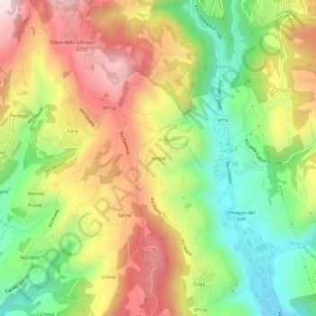
Name: Sengie topographic map, elevation, terrain.

Location: Sengie, Lugo, Grezzana, Verona, Veneto, Italy (45.55457 10.95933 45.59457 10.99933)

Average elevation: 1,759 ft

Minimum elevation: 827 ft

Maximum elevation: 2,799 ft

Gear up for your next adventure:

🔋Solar Power Banks - Keep your GPS and phone charged in remote wilderness areas
🔪Outdoor Multitools - Essential survival tools for gear repair and field use
🍳Camping Cook Set - Complete cookware for outdoor meals
💧Water Purification System - Clean water on the trail with reliable purifiers
🪶Compact Camp Shovel - Folding shovel for campsite tasks

As an Amazon Associate, this site earns from qualifying purchases at no extra cost to you.