
Pearl Point topographic map
Click on the map to display elevation.
About this map
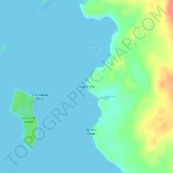
Name: Pearl Point topographic map, elevation, terrain.
Average elevation: 43 ft
Minimum elevation: -7 ft
Maximum elevation: 210 ft
Other topographic maps
Click on a map to view its topography, its elevation and its terrain.
Ducie Island
Canada > British Columbia > North Coast Regional District > Area A (North Skeena)
Average elevation: 3 ft
Zayas Island
Canada > British Columbia > North Coast Regional District > Area A (North Skeena)
Average elevation: 23 ft