
Make a donation
Gear up for your next adventure:
As an Amazon Associate, this site earns from qualifying purchases at no extra cost to you.
San Miguel topographic map
Click on the map to display elevation.
Make a donation
Gear up for your next adventure:
As an Amazon Associate, this site earns from qualifying purchases at no extra cost to you.
San Miguel
Peregrinaciones a la Gruta de Lourdes Una tradición no solo del pueblo sanmigueleño, sino de todos los devotos de la Virgen de Lourdes, que hacen sus peregrinaciones durante el mes de mayo hacia el Santuario que se encuentra en la elevación más alta de San Miguel.
Make a donation
Gear up for your next adventure:
As an Amazon Associate, this site earns from qualifying purchases at no extra cost to you.
About this map
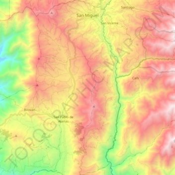
Name: San Miguel topographic map, elevation, terrain.
Location: San Miguel, Bolívar, 020301, Ecuador (-1.87614 -79.09567 -1.69255 -79.00751)
Average elevation: 8,445 ft
Minimum elevation: 4,577 ft
Maximum elevation: 11,900 ft
Make a donation
Gear up for your next adventure:
As an Amazon Associate, this site earns from qualifying purchases at no extra cost to you.
Other topographic maps
Click on a map to view its topography, its elevation and its terrain.