
Thank you for supporting this site ❤️
Make a donation
Make a donation
Gear up for your next adventure:
As an Amazon Associate, this site earns from qualifying purchases at no extra cost to you.
Canalpamba topographic map
Click on the map to display elevation.
Thank you for supporting this site ❤️
Make a donation
Make a donation
Gear up for your next adventure:
As an Amazon Associate, this site earns from qualifying purchases at no extra cost to you.
About this map
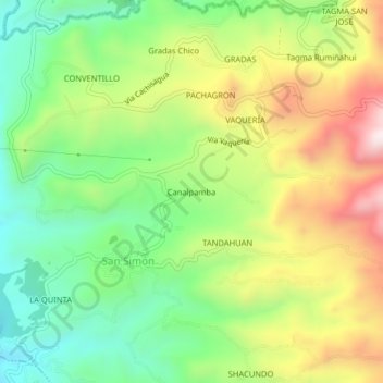
Name: Canalpamba topographic map, elevation, terrain.
Location: Canalpamba, San Simón, Guaranda, Bolívar, 020150, Ecuador (-1.65408 -79.00335 -1.61408 -78.96335)
Average elevation: 8,944 ft
Minimum elevation: 8,041 ft
Maximum elevation: 10,233 ft
Thank you for supporting this site ❤️
Make a donation
Make a donation
Gear up for your next adventure:
As an Amazon Associate, this site earns from qualifying purchases at no extra cost to you.