Geolocate

Point Cumana topographic map

Click on the map to display elevation.

About this map

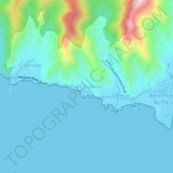
Name: Point Cumana topographic map, elevation, terrain.

Location: Point Cumana, Diego Martin, 110712, Trinidad and Tobago (10.66320 -61.59962 10.70320 -61.55962)

Average elevation: 230 ft

Minimum elevation: 0 ft

Maximum elevation: 1,450 ft

Other topographic maps

Click on a map to view its topography, its elevation and its terrain.

Trinidad

Trinidad and Tobago > Diego Martin

Average elevation: 128 ft

Maraval River

Trinidad and Tobago > Diego Martin > Maraval

Average elevation: 161 ft

Gear up for your next adventure:

🖼️Topo Map Wall Art - Decorative topographic prints of famous peaks and regions
🪶Survival Guide Book - Expert advice for emergency preparedness
🛡️Bear Spray Outdoor - Protection in bear country hikes
🧺Microfiber Travel Towels - Compact and fast-drying towels for trail use
🔌Solar Panel Charger - Charge gear sustainably outdoors

As an Amazon Associate, this site earns from qualifying purchases at no extra cost to you.